The Long Shadow of a Mountain Range on Rainfall
A mountain rain shadow explains why rainfall differs across a range and helps you connect seasonal winds, terrain, and moisture sources to local climate.
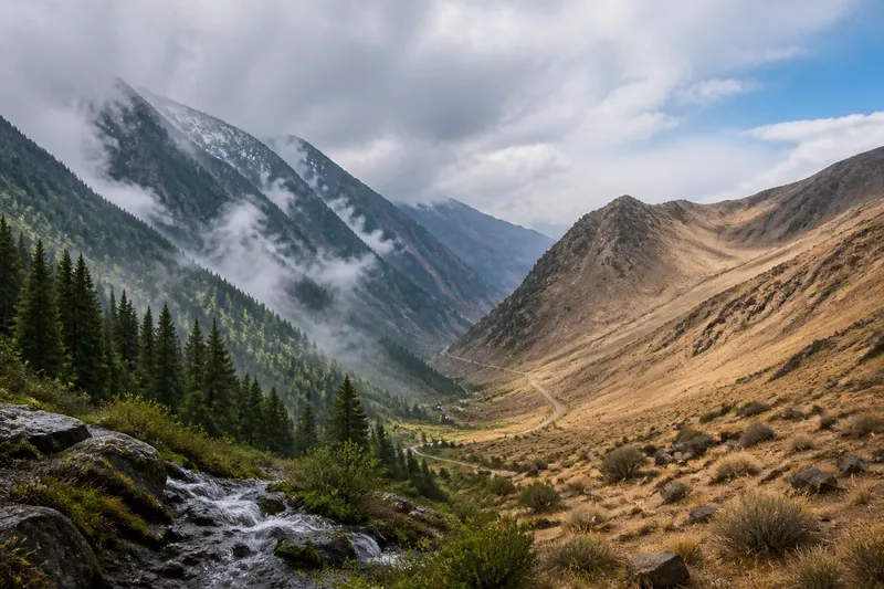
A mountain rain shadow can make one side of a range wetter than the other. The contrast depends on where moist air comes from, how the terrain redirects it, and whether winds change with the seasons.
Follow the air across the range rather than assuming the crest creates a sharp climate boundary. This distinction helps explain both broad regional patterns and the wetter or drier pockets near passes and valleys.
Mountain rain shadows begin with rising and sinking air
The windward side faces incoming airflow; the leeward side lies downwind. When moist air meets rising terrain, it is pushed upward. The air cools as it rises, and water vapor may condense into clouds and precipitation. After crossing the crest, air descends and warms, which tends to make further cloud formation less likely.
That sequence can produce a rain shadow: uplift and precipitation on the windward side, followed by comparatively drier conditions downwind. “Comparatively” matters. A leeward slope is not necessarily rainless, and a windward slope is not wet in every season.
Start with the likely moisture source and the direction air travels from it. A coastline west of a mountain range matters only if winds commonly carry air inland from the west during the period you are examining.
Use the landscape to identify the likely airflow route
Think of a mountain range as terrain that can redirect, lift, or channel air—not as a solid wall. A broad, high crest may force substantial uplift. A pass can let some airflow through, while neighboring ridges can create smaller sheltered areas.
Say you are comparing two valleys separated by a high ridge. If moist air usually arrives from the west, the western slope is likely to face the incoming flow. The eastern valley may receive less precipitation from that airflow, though other winds or weather systems can still bring it rain.
For a first explanation, write down three things: the moisture source, the direction of incoming air, and the terrain the air encounters. Then ask whether a pass, valley, or neighboring ridge changes the route.
Choose a seasonal or local explanation when needed
Trace one dominant airflow
This approach fits a broad range where winds commonly arrive from the same direction and carry moisture from a sea or another damp region. Air first reaching the range may rise and lose moisture; the downwind side may then be relatively dry. This explanation is less useful if winds shift direction or another range interrupts the airflow.
Compare wet and dry seasons
In some regions, prevailing winds shift during the year. A slope may face moist air in one season and drier or differently directed air in another. Compare seasonal rainfall and wind direction rather than assigning the entire range one permanent windward side.
Account for elevation and nearby terrain
A tall crest may force more uplift than a low pass, while a gap can channel air through the range. Valleys may guide or shelter airflow. These local effects help explain why nearby slopes and settlements can have different exposure, but elevation alone cannot identify the moisture source.
Check each clue before deciding what the pattern means
- Check whether a likely moisture source lies upwind; if it does, trace airflow from it, but if not, consider another source or weather system.
- Check the prevailing wind for the season in question; if it crosses the range, assess windward and leeward exposure, but if it shifts, compare seasons separately.
- Check whether the crest is high and continuous; if it forces air upward, consider uplift, but if low terrain or gaps dominate, account for airflow passing through.
- Check for passes and valleys along the route; if they channel air, expect local differences, but if they do not affect the route, focus on the broader range.
- Check rainfall on both sides over the same period; if one side is consistently drier, a rain-shadow explanation may fit, but if the contrast varies, look for seasonal or local causes.
- Check whether a map shows annual or seasonal conditions; if it combines the year, consult seasonal descriptions, but if it isolates the relevant season, use it for that period only.
- Check vegetation only as supporting evidence; if it matches the airflow and rainfall pattern, treat it as a clue, but if it conflicts, consider soil, temperature, land use, or water access.
A rain shadow is a tendency, not a line drawn neatly along a crest. Moisture can cross a range, especially through passes or under changing weather. A leeward region may also receive rain from another direction.
Rainfall may decline with distance from a crest, vary with altitude, or change between a valley floor and an exposed slope. Broad climate maps can show the regional pattern while hiding these smaller transitions. Cloud cover can suggest uplift, but a brief weather snapshot cannot establish a usual climate.
What should you ask about a mountain rain shadow?
Does every mountain range create a rain shadow?
No. The effect depends on moist air reaching the range and being forced upward. A range may have little influence if the air is dry, winds do not cross it, or other weather patterns dominate.
Can the leeward side still receive rain?
Yes. Air can retain moisture after crossing a crest, and leeward areas may receive precipitation from other winds or weather systems. A rain shadow describes a relative reduction, not a promise of dry conditions.
Why can one slope be wetter than a nearby valley?
The slope and valley may differ in exposure, elevation, or the route air takes through the terrain. A slope facing incoming moist air may receive more uplift, while a valley behind a ridge may be sheltered.
Can the windward side change during the year?
Yes, where prevailing winds shift seasonally. One side may face moist airflow in one season and drier or differently directed airflow in another, so seasonal rainfall can give a clearer explanation than a single annual label.
Work through a seasonal coastal-range example
Imagine a map with a coastal range west of an inland basin and a pass through the crest. For this invented situation, assume the wet-season wind commonly carries moist air inland from the coast, while the dry-season wind arrives from a different direction. These are hypothetical inputs, not claims about a real place.
First, trace the wet-season airflow from the coast toward the range. It reaches the western slope before crossing the crest, so that slope is the likely windward side. Next, follow the air over the crest: the basin may receive less precipitation from this flow, but the pass could allow some moist air through. The likely answer for the wet season is a relative rain shadow in the basin, not a completely dry zone.
Then assess the dry season separately. Because the assumed wind comes from a different direction, the wet-season label cannot automatically describe exposure during this period. The tradeoff is a more nuanced explanation: seasonal winds account for the broad contrast, while the pass may soften it locally. If you are reading your own mountain rain shadow, keep the season, moisture source, and route through the terrain together; none of them alone settles the explanation.