When a Border Follows a River, Which River Line?
Learn how a river border is defined by treaty language, surveyed coordinates, or a named channel, and how to read the relevant maps before drawing conclusions.
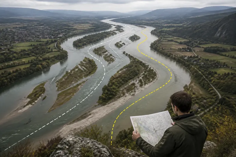
A river border is defined by its source documents, not by whichever line looks clearest on a map. A treaty may name a bank, a channel, or surveyed coordinates, and those choices can produce different boundary lines along the same waterway.
A river border needs a defined reference
On a map, a river may appear as one stroke. On the ground, it may include a navigable channel, shallow side channels, islands, and exposed riverbed. A border description needs to identify which feature counts; otherwise, a map reader cannot safely infer the boundary from the water’s outline.
Boundary documents may use terms such as these:
- Bank: a named river edge, as described in the governing text or survey. The document may need to clarify which bank and how it is identified.
- Centerline: a line defined by a particular agreement, survey, or mapping method. The term alone does not tell you how the channel’s edges or center were established.
- Thalweg: a line associated with the deepest part of a channel. The document and applicable interpretation determine which channel and what method matter.
- Coordinates or a surveyed line: a route recorded as fixed points or a mapped boundary, rather than a line inferred solely from current water.
These terms are not interchangeable. Read the actual boundary description and any definitions it incorporates before tracing a line.
Start with the document, then compare the maps
Use this sequence to assess a map without treating it as a legal ruling:
- Identify the source. Record the map title, publisher, date, and any cited treaty, survey, or boundary authority. If the source is missing, treat the line as illustrative.
- Read the boundary wording. Note whether it names a bank, centerline, thalweg, channel, coordinates, or an official map. If the wording points to a separate document, locate that document before drawing conclusions.
- Check the map legend and scale. See whether the line marks a political border, watercourse, or generalized feature. If the symbol covers nearby details, do not assume it precisely follows the river.
- Compare dates and purposes. A hydrographic map may depict channels, while a political map emphasizes jurisdiction. If their lines differ, first ask whether they represent different features or dates.
- Separate observation from interpretation. Satellite imagery can show visible water and landforms. If the question is where the legal boundary lies, use authoritative records and seek qualified guidance where needed.
Say you are preparing a classroom map and have an older official boundary sheet plus a recent satellite image. The sheet identifies a surveyed boundary line; the image shows water in a different location. First, record both source dates and inspect the sheet’s legend and cited documents. Next, label the watercourse as current imagery and the boundary as the surveyed line shown by that source. The result is a map that distinguishes what is visible now from what the official sheet records, without claiming that the image changed the legal boundary.
Do not assume every channel change has the same effect
Boundary outcomes after river changes depend on the governing instruments and the interpretation applied to them. Some arrangements may treat gradual channel movement differently from an abrupt diversion, but there is no single rule that resolves every international or local boundary. A general map reader should avoid deciding jurisdiction from the physical change alone.
Also distinguish a watercourse’s appearance from the legal question. A channel may shift, divide, or become partly dry; a boundary description may refer to a particular feature, a recorded line, or a method whose application requires official interpretation. The relevant treaty, survey, or boundary authority is the place to check.
- If the document names coordinates, compare the map’s boundary line with those recorded points; if they are absent, seek the cited survey or an authoritative map.
- If the document names a bank, check whether it specifies which bank and how the edge is defined; if not, do not choose an edge from imagery alone.
- If the document names a centerline, look for its definition or incorporated mapping method; if neither is available, mark the line as uncertain rather than inventing a center.
- If it names a thalweg, check which channel the source identifies and how it treats branches; if that information is unclear, ask the relevant boundary authority.
- If two maps disagree, compare their dates, legends, scales, and cited sources; if they depict different purposes, label those purposes instead of treating one as automatically wrong.
- If the question affects land rights, jurisdiction, or navigation, collect the relevant official documents; if uncertainty remains, consult the responsible public authority or a qualified legal professional.
Questions readers ask about river borders?
How is a river border centerline identified?
There is no universal field rule implied by the word alone. Check the boundary document for a definition, survey, or incorporated mapping method; without one, a general map cannot establish the precise legal line.
Does a river border move when the channel changes?
Not necessarily. The governing wording and applicable interpretation determine whether a boundary follows a changing feature or remains tied to a recorded line.
Which branch counts when a river splits?
The boundary source may identify a branch or define a method for locating the line. Visible water volume by itself does not settle which branch has legal significance.
Can satellite imagery establish a border?
Imagery can help show visible water and landforms at a particular time. It does not by itself establish the legally recognized boundary, so check authoritative documents for that question.
Label uncertain lines honestly
For an atlas, classroom exercise, or general map, state what the line represents and cite its source when possible. If the source does not explain how the border relates to the river, label the depiction approximate rather than implying that a visible channel determines jurisdiction.
For an actual boundary question, gather the relevant treaty text, official map, and survey records, then contact the responsible authority or a qualified professional if interpretation matters. A careful river border description identifies not just the watercourse, but the document that gives the line its meaning.