Reading a Port Through Its Routes
Read a port through its routes to identify the inland corridors, coastal passages, and bottlenecks that shape how a harbor connects distant places.
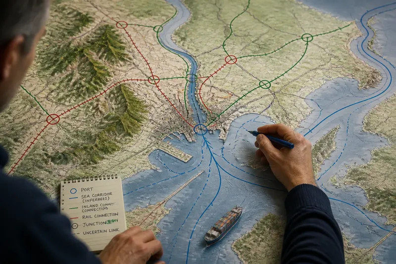
Read a port through its routes by tracing the corridors that carry inland traffic to the coast and the sea passages that link the harbor to other shores. A harbor’s location shows where it sits; its connections show which places can plausibly reach it and where those routes narrow, branch, or end.
Use a map to identify possible links, not to claim how much traffic they carry. A river, rail line, channel, or highway marks a geographic connection, but current service and cargo use require other evidence.
Start with a map that reveals the port’s setting
Choose a map that shows the coastline, waterways, landforms, and transport links. A physical map can reveal river mouths, mountain barriers, and lowland corridors. A road or rail layer adds built connections between the harbor and inland places.
Check the legend before interpreting lines. A blue line might mark a river or a shipping route, depending on the map. If using an online map, switch layers to avoid confusing overlapping symbols. Include enough surrounding sea to see nearby ports, islands, and straits.
Record the map’s source and date if they are provided. A missing rail spur or channel on a general map may reflect its level of detail, not a lack of connection.
Trace a port’s inland routes before judging its reach
Begin at the harbor and follow each visible inland link to a junction, destination, or clear break. Look for river channels, canals, railways, highways, and roads connecting terminals to larger networks. Write down the places each line appears to connect: a city, border crossing, river basin, or industrial area.
Notice where transport modes meet. A river may lead toward an inland town, while a railway continues from there to other destinations. A highway may branch toward multiple cities. These patterns suggest possible access, but the map alone cannot establish how often a route is used or whether it carries freight.
Imagine a fictional harbor at a river mouth. On the map, a navigable-looking river runs inland to a town, while a rail line reaches a junction and branches toward two other towns. Trace the river to the first town, then trace both rail branches from the junction. Your resulting sketch shows a water connection to one inland place and rail connections toward two others; it does not establish that all three routes currently carry port cargo.
Follow the sea corridors around coasts and barriers
Start with neighboring ports and coastlines, then trace plausible passages toward larger coastal gateways or open water. A ship may follow a sheltered coast before crossing a sea, or pass through a strait between islands and mainland.
Do not treat a straight line across a map as a confirmed shipping route. Coastlines, channels, water depth, weather, currents, and navigation rules can shape a usable passage. Mark broad corridors where a general map suggests a connection, and label them as inferred unless the map provides route data.
Use junctions and bottlenecks to compare port connections
Junctions are places where routes meet or divide. Bottlenecks are passages with few apparent alternatives, such as a narrow strait, mountain pass, bridge, or channel. A port linked to several routes may have multiple ways to reach inland or overseas destinations; a route dependent on one narrow passage may have fewer geographic alternatives.
Compare a harbor with a nearby port using the same map type and scale. Trace each port’s inland links, sea corridors, and route breaks. One may connect more directly to a river basin, while another may have a clearer coastal passage. These observations describe the mapped network, not a ranking of economic importance.
Estimate a port’s hinterland from connected corridors
A port’s hinterland is the inland area it can serve through connected transport routes. Do not draw it as a circle around the harbor. A distant town on a direct rail corridor may be more accessible on the map than a nearby place separated by rough terrain or a missing link.
Trace routes beyond their first destination and mark transfer points, detours, and gaps. Separate what the map depicts from what you infer: a railway is a visible connection, while regular freight service is a claim that needs current information.
Which questions help you read a port’s routes?
Does a port serve only the nearest city?
Not necessarily. Follow road, rail, river, and canal links beyond the nearest urban area to see which other places share a corridor. A nearby city may also connect more directly to a different harbor.
Does the shortest line on a map show a ship’s route?
No. A straight line may cross land or ignore a channel, island, or navigational restriction. Treat it as a rough direction unless a source documents the actual passage.
What if the map shows no shipping lanes?
Use coastlines, islands, straits, and neighboring ports to sketch plausible sea corridors. Mark these as inferred connections rather than confirmed routes.
Can a small harbor connect distant places?
It may connect to a larger inland network or sit along a coastal corridor. The map can show those possible links, but the harbor symbol’s size does not establish how much traffic it handles.
Record observations with decisions attached
Sketch the harbor on tracing paper or in a notes app. Use one color for inland connections and another for sea corridors. Add arrows only when the map indicates direction; otherwise, draw plain lines and label uncertain links.
- Check whether the map labels a river as navigable; if it does, mark a possible water corridor inland, but if it does not, label the river connection unconfirmed.
- Check whether a rail line visibly reaches the harbor or a terminal; if it does, trace it to its next junction, but if it stops short on the map, note the gap and avoid claiming a direct rail link.
- Check whether a highway connects the port to an inland junction; if it does, mark the junction and branches, but if the road ends before the network, record the endpoint instead of extending it by assumption.
- Check whether a strait or channel lies between the harbor and another coast; if it does, sketch that passage as a possible corridor, but if the map does not show a navigable route, mark the connection uncertain.
- Check whether a route branches toward more than one destination; if it does, label each branch separately, but if it does not, record the single visible destination without implying wider reach.
- Check whether a second transport mode meets the first at a junction; if it does, mark a possible transfer point, but if none appears, do not infer a transfer from proximity alone.
Keep the legend or note the map source beside your sketch. The record should make clear which lines are visible, which connections are inferred, and what information remains unknown.
Distinguish a gateway from a stop along a sea corridor
A gateway connects a coastal entry point with inland routes. A through-route stop lies along a coastal or ocean corridor, though it may have fewer visible connections to the interior. A harbor can serve both roles.
Look at the route pattern on each side of the port. Several inland corridors converging there suggest gateway potential; a strong chain of coastal links with few inland routes suggests a more limited mapped hinterland. Treat these as geographic clues, not definitive labels.
Reading a port through its routes is clearest when you separate the visible network, the connections geography makes plausible, and the services that need current confirmation. Follow each corridor to its junction or break, then use the port’s connections—not just its position on the coast—to describe what the map supports.